We deliver high-utility risk mitigation solutions across South Central South Dakota. Built on a singular-expert profile, our operations combine 10+ years of fire investigation and 15+ years of EMS emergency response experience with advanced field diagnostics.Our Core Field Capabilities:
🌾 Agricultural Field Mapping (Ag-Ops)
🏭 Feed Mill & Grain Diagnostics (Mill-Scan)
🏡 Residential Safety Audits (Home-Safe)
🔬 Post-Loss Cause & Origin Forensics
ABOUT OUR FIRM
Elite Risk & Mitigation Services, LLC is a specialized safety consultancy, precision property layout mapping firm, and forensic post-loss investigation agency. Operating across South Central South Dakota, our firm delivers high-utility risk mitigation solutions designed to protect critical infrastructure, local business operations, and private estates .Our corporate mission anchors on three structural safety pillars:Advanced Technological Precision: We deploy cutting-edge field diagnostics, including all-weather industrial drone platforms and handheld under-load electrical thermal imaging, to eliminate operational risk. Proactive Hazard Interception: We replace outdated compliance checklists with data-driven diagnostics to catch critical failures before they trigger catastrophic structural or financial asset losses. Defensible Field Intelligence: All forensic site inspections, mapping operations, and post-loss cause and origin investigations deliver unassailable, high-contrast evidence packages tailored for insurance subrogation tracking. By modernizing field safety through advanced aerial and thermal data nodes, our firm insulates regional agribusiness cooperatives, small business owners, and rural households from preventable disaster.
Team
Owner & Lead Consultant
Phillip Lane
Inspector. AElite Risk & Mitigation Services, LLC is directed by a dedicated public safety professional with over 15 years of combined emergency medical response, firefighting, security, and law enforcement experience. By translating strict code enforcement, tactical safety, and forensic methodology into private sector risk mitigation solutions, the firm provides an unmatched level of technical field execution across South Central South Dakota.Professional Core Credentials:10+ Years as a Fire Investigator & 8+ Years as a Certified Fire Inspector: A proven track record managing strict legal chain-of-custody evidence packaging, arc-mapping, and microscopic metallurgy copper wire tracking. This extensive asset defense background ensures all post-loss cause and origin investigations yield unassailable, court-defensible data for insurance subrogation files.10+ Years Structural & Wildland FirefighterA dual-service background covering both structural fire containment and wildland fire behavior. This provides deep, firsthand knowledge of fire tracking, fuel loads, and fire pathways to establish airtight wildfire defensible perimeters for local properties.13+ Years of Security and Law Enforcement Over a decade of joined asset protection, high-tier security management, and law enforcement operations. This combined background guarantees absolute precision, discretion, and strict data integrity when processing commercial site risk evaluations or handling high-liability property data.15+ Years in EMS Emergency ResponseOperating calmly under high-stress conditions to protect life and property in local communities. This extensive emergency medical response background provides the critical diagnostic lens required to evaluate environmental path hazards, fall vectors, and egress blockages for residential senior "Age-in-Place" safety audits.Industrial Drone & Thermal Imaging SpecialistBlending decades of multi-agency public safety experience with advanced all-weather industrial drone mapping platforms and under-load thermal diagnostics to isolate hidden combustible dust or electrical faults standard check-list inspectors miss
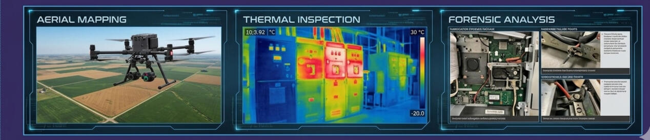
OUR PROFESSIONAL CAPABILITIES & CORE SERVICES🌾 1. Precision Farm Layout & Ag Field Mapping (Ag-Ops)- Service Overview: We deploy advanced, all-weather industrial drone platforms to capture high-resolution aerial imagery and stitch together centimeter-accurate layouts directly from our mobile truck-bed field rig.- Technical Deliverables: Full 2D aerial asset mapping, high-definition topographic drainage surface modeling, and comprehensive bank pre-purchase due-diligence data reporting.- The Operational Advantage: All image rendering and telemetry data processing are executed 100% offline at the field command station, completely bypassing rural cellular connectivity limitations.- Target Clients: Agricultural Lenders, Farm Managers, Co-op Land Developers, and Rural Property Buyers.🏭 2. Commercial Grain Elevator & Feed Mill Diagnostics (Mill-Scan)- Service Overview: High-level industrial hazard assessments targeting catastrophic dust mitigations, structural electrical system tracking, and livestock infrastructure integrity.- Technical Deliverables: Rigorous NFPA 61 combustible dust hazard sweeps, handheld under-load electrical panel thermography to catch micro-arcing wire stress, and precision livestock crate stray-voltage structural triage.- The Operational Advantage: We utilize high-sensitivity thermal tracking cameras and volatile gas sniffing equipment to locate hidden heat signatures and deterioration inside active facilities before a structural fire or explosion can ignite.- Target Clients: Agribusiness Operators, Feed Mill Managers, Grain Elevator Superintendents, and Commercial Safety Directors.🏡 3. Premium Residential Safety & Senior Audits (Home-Safe)- Service Overview: Comprehensive environmental risk evaluations designed to insulate homeowners and vulnerable family members from preventable injuries and property liabilities.- Technical Deliverables: Specialized EMS-driven senior "Age-in-Place" fall path hazard triage, rental property landlord firewall compliance diagnostics, and WUI (Wildland-Urban Interface) wildfire defensible space mapping.- The Operational Advantage: Backed by 15+ years of active emergency medical response experience, we systematically audit structural flow paths, entryway threshold gradients, light-level saturation points, and tap-water scalding limitations to give families true safety peace of mind.- Target Clients: Aging Adults, Concerned Family Caregivers, Residential Landlords, and Property Managers.🔬 4. Post-Loss Cause & Origin Forensics (Forensic Field Tech)- Service Overview: Rapid-response, technical on-scene investigation services to isolate, document, and definitively prove the root cause of catastrophic property losses.- Technical Deliverables: On-scene copper wire metallurgy microscopy scans, strict legal chain-of-custody evidence packaging, arc-mapping documentation, and comprehensive forensic cause-and-origin reporting.- The Operational Advantage: Backed by over a decade of fire investigator and fire service experience, we deliver highly technical, unassailable, and court-defensible data packages specifically structured to drive successful insurance company subrogation recovery lawsuits.- Target Clients: Insurance Claims Adjusters, Special Investigation Units (SIU), Corporate Subrogation Attorneys, and Risk Underwriters.📊 Fee Structure & Service Scheduling- Consulting Model: All assignments are handled via a dedicated, single-operator specialist configuration.- Rate Tracking: Standard field diagnostic rates, legal deposition tracking, and advanced technical reports are structured transparently under customized commercial consulting agreements.- Booking Portal: Use our secure scheduling matrix below to lock in an offline property sweep, drone mapping window, or emergency post-loss fire scene inspection panel.
📊 Our Fixed Tiered Service Matrix🔬 Post-Loss Forensics & Investigation- First 2 Hours (Flat Rate): $700.00- Hourly Rate (After 2 Hours): $350.00 / hour- Includes: Post-loss fire Cause & Origin (C&O) tracing, electrical arc-mapping via digital metallurgy microscopy, environmental accelerant vapor sniffing, physical evidence sifting/preservation, and expert written report construction for insurance carrier legal teams.🌾 Precision Farm Layout & Field Mapping (Ag-Ops)- First 2 Hours (Flat Rate): $450.00- Hourly Rate (After 2 Hours): $225.00 / hour- Includes: 2D Orthomosaic aerial boundary tracking via specialized processing software, digital topographic surface modeling for drainage/erosion controls, and vehicle routing clearance mapping for massive farm implements.🏭 Livestock & Industrial Diagnostics (Mill-Scan)- First 2 Hours (Flat Rate): $450.00Hourly Rate (After 2 Hours): $225.00 / hour- Includes: Pre-purchase ag due-diligence audits, NFPA 61 dust hazard analysis, confinement enclosure diagnostics (NEMA 4X corrosion checks), mechanical bearing/gearbox thermal scans, and high-sensitivity stray-voltage frame tracking on metal crates and water lines.🏡 Residential Forensic Audit (Home-Safe)- First 2 Hours (Flat Rate): $350.00- Hourly Rate (After 2 Hours): $100.00 / hour- Includes: Under-load breaker panel thermal sweeps, Type X garage firewall tracking, senior "Age-in-Place" safety consults (EMS fall triage, digital ramp gradient checking), landlord pre-marshal audits, and WUI wildfire defensible space certifications.🛡️ Regional Travel & Border Policies-Local Service Radius: $0.00 additional travel fees apply to any assignment site located within a standard 40-mile round trip of our operational base.- Extended Service Area: A flat $40.00 Travel Surcharge is automatically applied to any assignment location requiring more than a 40-mile round trip to insulate operational margins against road transit time.- Strict Data Isolation: All property mapping models, industrial risk diagnostics, and forensic files are processed and saved 100% offline on secure physical hardware to safeguard sensitive client data.